The race takes place in the mountainous and woody terrain of the Northern Urals. The old Ural Mountains (formation is about 500 mln years back in time) are the land boundary between the parts of the world Europe and Asia, both making the largest continent of the earth.
The first half of the route (21 km) runs uphill to the summit of Mt.Konzhakovsky Stone (1569m). The way back - same route downhill.

Mt.Konzhakovsky Stone is the highest point of the Ural Mountains on the territory of the Sverdlovsk province, the area of which makes up 194,8 thousand sq.km.
In as far as 480 km in the northern direction there is a higher point - Mt.Telposiz (1617m) located in the Republic of Komi. In the southern direction Mt.Konzhak reigns over for as much as 570 km till Mt.Bigger Iremel (1582 m), located in Bashkortostan between ridges of Bakty and Avalyak.
If upon the top of Mt.Konzhak you throw your glance alike a ray of light westwards along the 60th latitude none of the obstacle will hinder your sight for as long as 3 thousand kilometers. Throughout the Eastern European plain and the Baltic waters you will be next to the Greenwich meridian at Mt.Geusta (1883 m) of the Norwegian mountains. In the eastern direction the elevation of Mt.Konzhak's summit will allow you to cross the Western-Siberian plain, Central-Tungussk plateau and in 3200 km meet Mt. Korolenko (1649 m), located in the Patomsky hills, between rivers of Vitim and Chara.
The seat of Mt.Konzhak is unique - the mountain is a cross of almost equal geographical values - 59 40" of the northern latitude and 59 50" of eastern latitude.
Mt.Konzhak gives start to five rivers: Katysher, High-Bank, Northern Yov, Mid-Day, and Konzhakovka. It is along the right side of the latter that the marathon route takes place.
The closest residences to Mt.Konzhak are Kytlym settlement (25km), towns of Karpinsk (70 km) and Krasnoturinsk (80km).The bigger cities in the vicinity are Perm, Yekaterinburg, Chelyabinsk, Tyumen, Izhevsk, Kurgan, and Ufa.
What is in store for you?
The track lies in the mixed woods, taiga, tundra (with patches of alpine valleys) and on the rocky terrain of the Konzhak massif with surfaces like pebble, soil trail, stones, grass, boulders.
More details of the route
From the start the first 4-5 km run along the old-time timber road, mostly dry, compacted and graded with pebble, through brooks and swamps with alder-trees, firs, willows, growing around.
Then you rise a slope along rough pebble interchanging with soil track. On the sites of timber-cuts you see bushes of raspberries, mountain ashes, dog roses, fire-weeds. On top of the slope you will be fanned with either northern or western wind, and your eyes will rest on the picturesque view of the southern oval of the golden Kytlym cup.
Before you - as if they are on the palm of your hand: Mt.Sukhogorsky Stone (1200m), Mt.Seven Men (1036m), Hillocks (1064 м), Mt.Cap (956m) and a huge dome of Mt.KosvinskyStone (1519m).
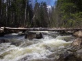
Further on the timber dragging road gets you almost to the river of Konzhakovka to reach which you have to dive into a narrow shadowy soft soil trail, lined with silver firs and fir-trees.
Crossing the stream over the logs will take you some 5-10 seconds. The trail then leads you to a stream drying off in summertime, then through mixed forest with meter-high ant-hills, carpets of bilberries and mountain cranberries to a clearing with a spring. That place encircled with high mountain ashes and a mighty cedar may resemble you something of a paradise.

The next two-three kilometers are most pleasant, the trail is wide, dry and soft, on both sides there are evergreens, spotted with huge roots of fallen trees and spectacular more than a century old cedars.
In 5 km from the spring you will step on the Glade of the Artists. Like an arena of an amphitheatre it is surrounded from its three sides with rocky giants - Guard's shoulder, first steps of the Konzhak and Mt.Trapezium. On the right below you there is a canyon of the Konzhakovka river. From this glade the heavily padded trail gets you through the dwarf forest, then through the knee-high bushes and then through rock falls to the Yov' gates pass.
A wide Yov's plateau is fully covered with grass and flowers, with damp soil provide you with a breathtaking panorama. On the right there is Mt.Southern Yov (1311m), in front of you - Mt.Northern Yov (1263m), further on across the belt of woods - Mt.Burtym (1148m). From this place at clear weather you may get a view of the magnificent Main Urals ridge (1425m) and the Denezhkin Stone ridge (1489m), being as far as almost hundred kilometers away.
The last 3 and a half kilometers you pace and crawl over sets of boulders, meet with random grassy clearings with some flowers, mountain onion, golden root, fed with crystal clear streams.
Finally you step on a grassy carpet of the pre-summit plateau at the height of 1500m. There is a memorial to the died. And it will take you final 10-15 minutes to get to the top of the most popular Urals mountain.
The organizers will offer you tea, drinks, snacks at five feed stations along the route. After finish you may enjoy swimming in a mountainous river and taste hot tea and food cooked on fire.